Naini Tal The Top and Hot Travel Destination of Uttarakhand, India
Courtesy : Mr. Navin Joshi "Buero Chief- Rashtriya Sahara" Nainital
Kumaon is a glittering jewel in the Himalayan necklace, blessed with scenic natural splendor and varied natural resources. Within panoramic Kumaon lies the district of Nainital the first recorded discovery goes back to the year 1841 when Mr. P. Barron a british officer moved by the scenic splendor of the place that he a house constructed by the name “ pilgrim cottage and gradually township sprung up around the lake.
Like most other hills district, Nainital also has a varied topography. Some of the important places in the district are Nainital, Haldwani Kalakhaungi, Ramnagar, Bhowali, Ramgarh, Mukteshwar, Bhimtal, Sattal and Naukuchia –Tal and most of these are of tourist interest.
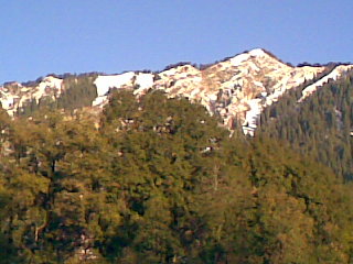
The hilly areas experience snowfall during winter, while in the plains the temperature soars to 45° c during summers.
Nainital used to be the summer capital of united provinces during the British period and continued to remain so for many years even after independence.
Nainital‘s wending expanse of scenic beauty is nothing short of romance with awe-inspiring and pristine mother nature. Nainital is well connected to different part of the country.
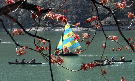
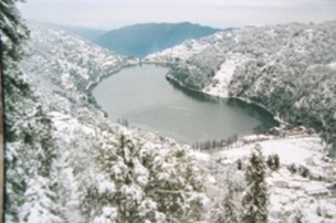
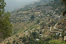
The City of Lake - Naini Tal
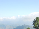
At a height of 1938 meters in the Central Himalaya of the Kumaon Region lies picturesque Nainital. Its snow –capped peaks, verdant valleys, Rolling Meadows and crystal lakes have beckoned lovers of nature since ages. Natural has been generous in endowing Nainital with natural beauty that transcends the ordinary and an abundance of flora and fauna.
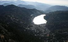
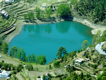
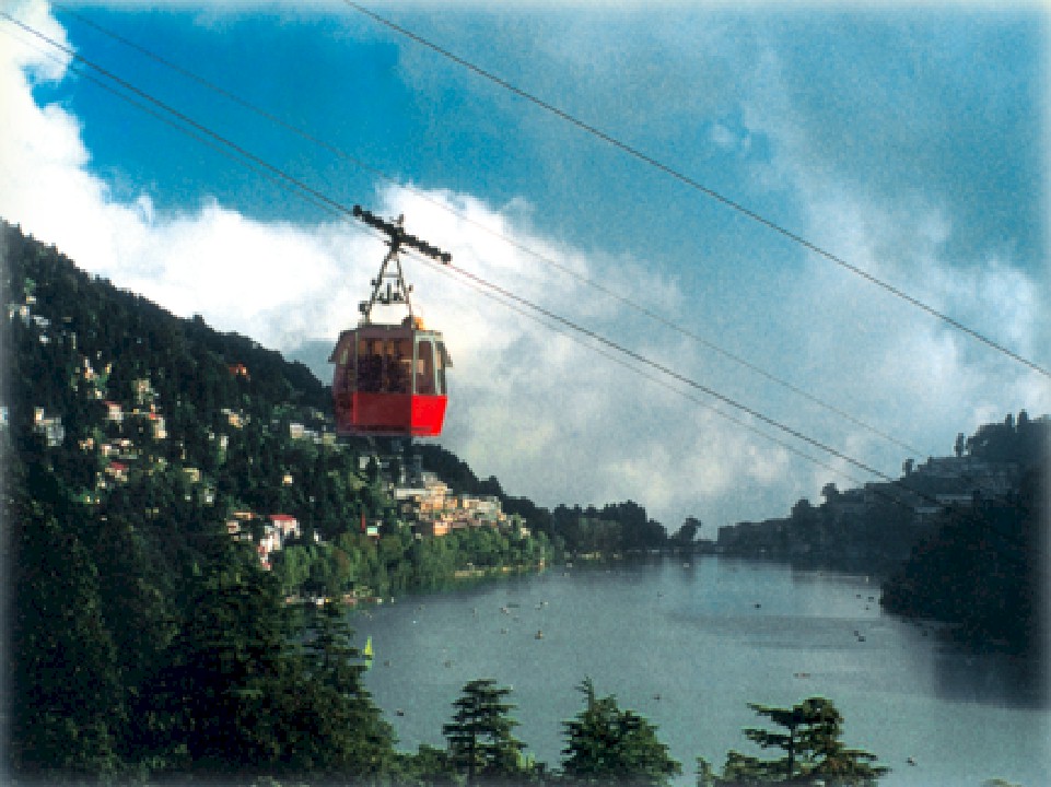
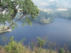
Dotted with Lakes, Nainital has earned the epithet of ‘Lake District ‘of India. The most prominent of the lakes in Naini Lake ringed by hills and named after the Goddess Naina.
A through of tourist flock of Nainital throughout the year to explore its historical sites, wildlife reserve, fruit orchards, sanctified sport and the panoramic environs very few hill stations of India can equal.
General Information -:
Area: 11.73 sq. Kms
Altitude: 1938 Mts
Season: Accessible Round The Year.
Clothing: Light woolens or cottons in summer and heavy woolens in winter.
Language: Hindi, English and Kumaoni (Local Language)
Air: Nearest Airport is at Pantangar
Rail: The Nearest Railway Station is Kathgodam (35 Kms) connected to Lucknow, Agra, Delhi and Howrah.
Road : Nainital is connected to all the major National / State Highways.
From Nainital the following places are directly connected by regular bus service.
Agra : 403 Kms
Almora : 64 Kms
Badrinath : 334 Kms
Bareilly : 140 Kms
Dehradun : 387 Kms
Delhi : 326 Kms
Haridwar : 310 Kms
Kausani : 117 Kms
Local transport: Paddle Rickshaws, Local Taxi & Horses for Limited Area
Like most other hills district, Nainital also has a varied topography. Some of the important places in the district are Nainital, Haldwani Kalakhaungi, Ramnagar, Bhowali, Ramgarh, Mukteshwar, Bhimtal, Sattal and Naukuchia –Tal and most of these are of tourist interest.
The hilly areas experience snowfall during winter, while in the plains the temperature soars to 45° c during summers.
Nainital used to be the summer capital of united provinces during the British period and continued to remain so for many years even after independence.
Nainital‘s wending expanse of scenic beauty is nothing short of romance with awe-inspiring and pristine mother nature. Nainital is well connected to different part of the country.
The City of Lake - Naini Tal
At a height of 1938 meters in the Central Himalaya of the Kumaon Region lies picturesque Nainital. Its snow –capped peaks, verdant valleys, Rolling Meadows and crystal lakes have beckoned lovers of nature since ages. Natural has been generous in endowing Nainital with natural beauty that transcends the ordinary and an abundance of flora and fauna.
Dotted with Lakes, Nainital has earned the epithet of ‘Lake District ‘of India. The most prominent of the lakes in Naini Lake ringed by hills and named after the Goddess Naina.
A through of tourist flock of Nainital throughout the year to explore its historical sites, wildlife reserve, fruit orchards, sanctified sport and the panoramic environs very few hill stations of India can equal.
General Information -:
Area: 11.73 sq. Kms
Altitude: 1938 Mts
Season: Accessible Round The Year.
Clothing: Light woolens or cottons in summer and heavy woolens in winter.
Language: Hindi, English and Kumaoni (Local Language)
Air: Nearest Airport is at Pantangar
Rail: The Nearest Railway Station is Kathgodam (35 Kms) connected to Lucknow, Agra, Delhi and Howrah.
Road : Nainital is connected to all the major National / State Highways.
From Nainital the following places are directly connected by regular bus service.
Agra : 403 Kms
Almora : 64 Kms
Badrinath : 334 Kms
Bareilly : 140 Kms
Dehradun : 387 Kms
Delhi : 326 Kms
Haridwar : 310 Kms
Kausani : 117 Kms
Local transport: Paddle Rickshaws, Local Taxi & Horses for Limited Area
|
Places of Interest Near Naini Tal
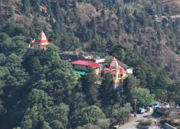
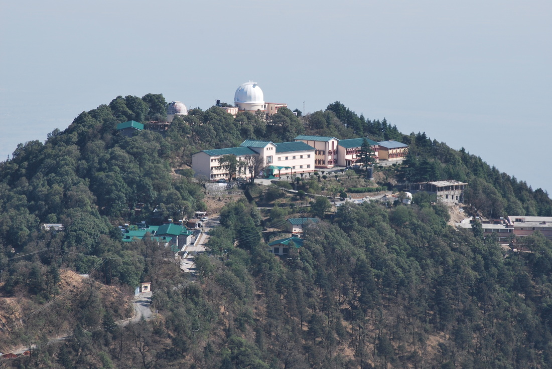
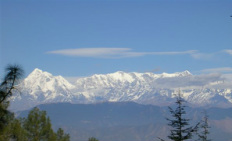
Naina Peak -: Naina Peak, the highest peak around Nainital, is at a height of 2610 Mts & 5.5 Kms from Nainital, commands a captivating view of the snow – clad Himalayan range. On a clear day, a wide range of the snow-clad Himalaya is visible and one can have a bird’s eye view of Nainital, one can either trek or go on horse back. Snow view -: A Scenic Spot-it offers a panoramic view of 250 Kms of the Himalayn range. The snow view peak, 2270 Mts is a popular vantage point in Nainital accessible by a ropeway or by horse and on foot. High Altitude Zoo -: Perched at an altitude of 2075 Mts 1.5 Kms Away from the bus station the zoo is a famous for housing a variety of species of animals living at higher altitude. Khurpatal -: 5 Kms from Nainital, the lake is a haven for anglers, and is inhabited by a number of fishes. It is situated on Nainital –Ramnagar Motorable road. Kilbury -: At an altitude of 2528 Mts An ideal place for a quiet weekend holiday and picnic Kilbury is part of a forest reserve and is rich in Flora and Birdlige. Forest rest house is available for accommodation with the permission of D.F.O Nainital. Hanumangarhi -: 1951 Mts Above and 3.22 Kms from Nainital, it is a place of religious interest, and is also famous for a spectacular view of the sunset. Land’s End -: At a 4 Kms trek from Nainital, 2118 Mts High, this hill offers a panoramic view of Khrpatal and the terraced fields on the side of the hill, it is accessible by horse also. Kainchi Temple -: At a distance of 16 Kms on the Almora - Ranikhet road one can also visit the temple complex of Kainchi. State Observatory -: Situated at a height of 1951 Mts 4.4 Kms from Nainital, the state observatory undertakes astronomical studies and optical tracking of artificial earth satellites. Main Markets / Shopping Bara Bazaar, Mallital Tallital Bazaar Mall Road Tibetan Market Bhotia Bazaar Accommodation -: Tourist Rest House Private Resorts and Hotels There are about more then 200 Hotels & Guest Houses in Nainital.
|
|
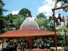
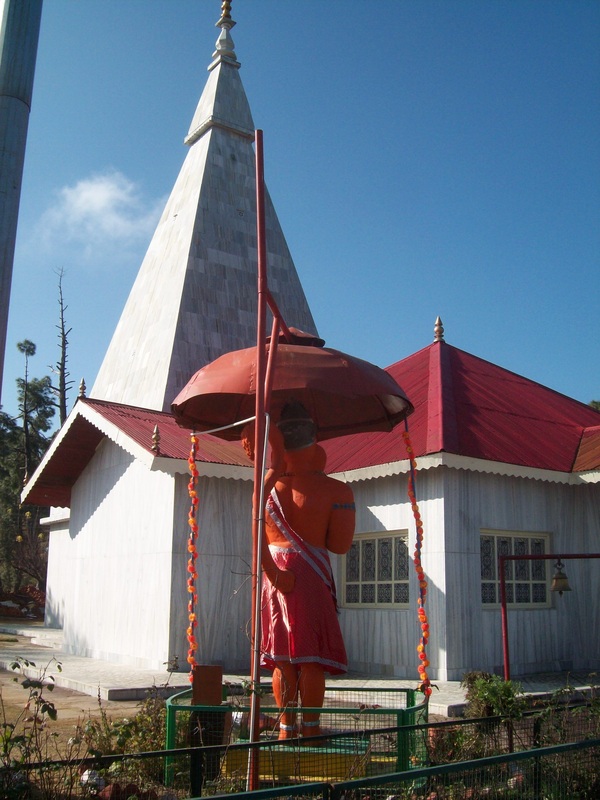
Ghorakhal -: Golu Devta Tample -: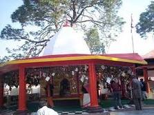
Ghorakhal -: Golu Devta Tample -: This temple is 4 Kms from Bhowali in Ghora Khal. Golu devta charms the devotee and the tourist with its alluring view of the down valley comprising Bhimtal. The place is also known for the Sainik School.
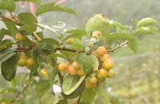
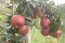
Ramgarh -: Situtated at an altitude of 1789 Mts on Bhowali - Mukteshwar road Ramgarh is known for a variety of Himalayan fruits and the spectacular view of the Himalayan ranges. The famous Poets Rabindra Nath Tagore and Mahadevi Verma have praised the serenity of this place and composed their poems ‘Geetanjali’ and ‘Dandhya geet’ here. Ramgarh also house a fruits processing factory run by the governments. General Information -: Altitude – 1789 Mts Season – Round The Year. Accessibility -: Rail: Nearest Rail Head is Kathgodam 48 Kms via Bhimtal and 51 Kms via Jeolikot - Bhowali Road : Well connected by motorable road 25 Kms from Nainital 51 Kms from Kathgodam 55 Kms from Haldwani 14 Kms from Bhowali Accommodation -: Tourist Rest House Private Resorts and Hotels -: Excursion :- in and around Naini tal
Jeolikot -: Jeolikot (1219 Mts) is famous as a Health Center, for its Butterflies, and also for Honey Mushrooms and Fruits, including Strawberries and Leechies, it produces.
Bhowali -: Situated at an elevation of 1706 Mts on Bhimtal, Ranikhet, Almora, Kausani and Pithoragarh motorable road, Bhowali is small township known for its Himalayan views. A sanitorium named after King Edward is situated here. Bhowali is a major export center for Himalayan Fruits like Apples Apricot, Plums, Pears and Peaches etc. General Information -: Altitude- 1706 Mts Season – Round The Year Languages – Hindi, Elglish and Kumaoni Accessibility -: Rail: Nearest Rail Head is Kathgodam 37 Kms via Jeolikot and 34 Kms via Bhimtal. Road: Situated at Haldwani – Almora National Highway. 37 Kms from Kathgodam 11 Kms from Nainital 53 Kms From Almora 50 Kms from Ranikhet. Accommodation -: Tourist Rest House Private Resorts and Hotels Bhimtal having an I-Land on The Lake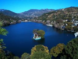
Bhimtal blessed with a pristine aura Bhimtal is just 22 Kms from Nainital. Bhimtal gets it name from the Mighty Bhima (one of the Five Pandava Brothers from Mahabharata) favoured by the tourist, Bhimtal has emerged as a different tourist destination with facilities like boating, fishing, rowing etc. available for the tourist. General information -: Altitude – 1370 Mts Season – Round The Year Accessibility -: Rail: Nearest Rail Head is Kathgodam 23 Kms from Bhimtal Road : Bhimtal is well connected by metalled road with al the major places in the region. 22 Kms From Nainital 11 Kms From Bhowali 4 Kms Short of Naukuchiatal 61 Kms From Ranikhet 64 Kms From Almora Private Taxies and Jeeps are easily available. Accommodation -: Tourist Rest House Private Resorts and Hotels Sat Tal - A Group of The Seven Lakes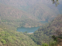
Sat Tal -: Situated at a distance of 24 Kms from Nainital, Sattal constitutes seven interconnected lakes and forms the most picturesque resort is the kumaon hills. Sattal is surrounded by a cover of thick forests.
Accessibility -: Rail: Nearest Rail Head is Kathgodam 35 Kms Via Bhimtal Road : it is well connected by road 12 Kms from Bhimtal, 13 Kms from Bhowali & 24 Kms from Nainital Private Taxies and Jeeps are also easily available from Bhimtal, Bhowali and Nainital. Accommodation -: Tourist Rest House Private Resorts and Hotel |
Ramnagar - The City of the Jim Corbett
Ramnagar -: Ramnagar is situated on the banks of the River Kosi and was set up by Commissioner Hennery Ramsay with the coming of the Broad-Gauge Railway Line, Ramnagar has become a very important town. One can visit the archaeological ruins of Dhikuli, the Garjiya Devi Temple and Sitabani while one is at Ramnagar 10 Kms from Ramnagar are the ruins of Kotabagh, which date back to the Chand Rulers. Kaladhungi has been part of Jim Corbett’s House, which now houses the Corbett Museum. The Corbett National Park is situated on the Banks of the Ramganga and is spread over the districts of Nainital, Bijnor and Pauri Before Kaladhungi, at Kamola "The Thimayya Farm" of the Kumaon Regiment of Indian Army Force is situated. From Ramnagar one can also go to Ramnagar one can also go to Ranikhet and Chaukhutia and beyond via Mohan.
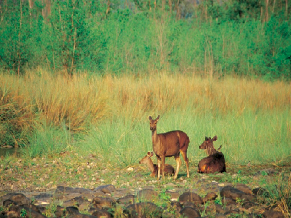
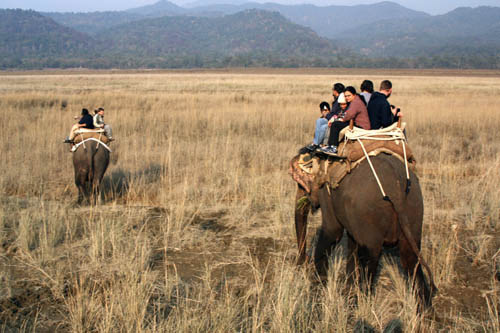
Season -: Round The Year Corbett National Park -: Extending over an area of about 520 Sq. Kms The Jim Corbett National Park was established in 1936. The first of its kind in India, the park is situated on the banks of the Ramganga River. The park attracts a number of tourists, as it is famous for a variety of flora and wildlife found here. The project tiger, assisted by the world wildlife fund fro nature, was launched here with the am to conserve the wildlife of this region. Accessibility -: Rail: Nearest Rail Head is Ramnagar (50 Kms), connected to Lucknow, Agra & Delhi.
Corbett Water Fall & Corbett Museum Kaladhungi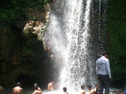
Corbett Water Fall -: The Corbett waterfall is situated 36 Kms from Nainital , on the Kaladhungi - Ramnagar road falling under the Ramnagar Forest Division. The waterfall stands at a distance of 3 Kms from the Kaladhungi main road. The fall with a drop of 20 mtrs is surrounded by a forest belt and camping sites with an abundance of birdlife and plant life. Some other added attractions for the Nature Walk museum, the adventurous camping sites etc. The easy availability of parking facilities makes the place an ideal picnic spot.
Accommodation -: Private Resort and Hotels Available. Kaladhugi -: If exploring Jim Corbett National Park is o your holiday agenda, don’t forget to make a detour to Kaladhungi. A romantic hamlet 35 Kms from the famous Corbett National Park, Kaladhungi has been an inseparable part of the endless tiger stories of Kumaon focusing around the legendary hunter Jim Corbett. The significance of Kaladhungi is clear from the fact that Jim Corbett chose this place as his residence. Today this unique home is a comprehensive museum housing souvenirs, related to Jim Corbett and his famous exploits. Season -: Round the Year Accessibility -: Rail: Nearest Rail Heads are Ramnagar & Kathgodam Road: Kaladhungi is 33 Kms (via Khurpatal ) from Nainital, 28 Kms via Haldwani, 30 Kms from Ramnagar & 55 Kms from Kashipur. Accommodation -: Tourist Rest House Private Resort and Hotels Available. Garjia Devi Temple
Garjia Devi Temple -: Situated at 14 Kms from Ramnagar on the way to Ranikhet is a huge rock in the midst of River Kosi. This place has been named Garjia Devi after the deity. The temple is visited by Thousands of devotees from different parts of the State & Country.
Accessibility -: Rail : Nearest Rail Head is Ramnagar, 14 Kms. Road : Garjia Devi Temple is situated on Ramnager – Dhangarhi- Ranikhet- Almora and Chaukhtia motorable roads . The temple is 82 Kms from Ranikhet and 126 Kms from Almora. Accommodation -: Tourist Rest House (Ramnagar) Private Resort and Hotels Available Mukteshwar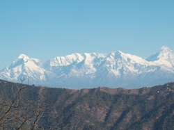
Mukteshwar -: Situated at an altitude of 2286 Mts on Bhowali - Devidhura road, Mukteshwar is a small hill station covered with a thick wooed forest and offers a majestic view of the Himalaya, near Muktewhar is stone hole of Chauli ki Jali dedicated to Lord Shiva. On a moonlit night, the place offers a spectacular view of the sparkling town of Almora and the majestic peaks of Adi Nampa of Nepal stretching up to the Chaukhamba Peaks of Garhwal Himalaya. It is also famous for more than the hundred year old Indian veterinary research institute campus.
Accessibility -: Rail: Nearest Rail Head is Kathgodam 73 Kms via Bhimtal and 76 Kms via Jeolikot –Bhowali. Road : Nainital 50 Kms Bhowali 39 Kms and Ramnagar 25 Kms Accommodation -: Tourist Rest House Private Resorts and Hotels |

Naukuchia Tal, Harish Tal & Lokhan Tal
Naukuchiatal-: Naukuchiatal is a lake having religious significance, 4 kms from Bhimtal, the lake is nine-cornered beautiful water body with dresses up as a festive randezvous on the occasion of ganga dussehra. It is believed that one attains nirvana if he manages to see all its nine corners.
Accessibility -:
Rail: Nearest Rail Head is Kathgodam 27 Kms
Road : Naukuchiatal is well connected with other areas.
195 Kms from Bhowali
26 Kms from Nainital
4 Kms from Bhimtal
Accommodation -:
Tourist Rest House
Private resort and hotels are also available.
Hotels at Bhimtal
Harish Tal and Lokhan Tal -: These Lakes are situated at a distance of 72 Kms from Nainital in the Okhalakanda Block near the Village Gotia. The two Lakes are at a distance of 1 km. from each other and both have a surface area of about 2 Sq. Kms each. One has to walk 5 Kms from Khansyu (a local village) in order to reach these lakes.
Almora : The Switzerland of India
Almora, the capital of kumaon region is known as “Switzerland of India” A picture postcard district at the lofty height, full of salubrious nature, misty mountains, green valleys emerald lakes, ubiquitous rivers, fruit lades orchards, Almora is a travelers paradise. It was the capital of Chand dynasty (toll 18th century) before the British takeover. The town perched on a saddle shaped ridge in mid of the Himalayas. The historical Chand fort, beautifully carved wooden homes, a pleasant Almora exciting location.
Accessibility -:
Nearest Airport -: Pantnagar (127 Kms),
Nearest Rail Head -: Kathgodam (90kms),
By Road -: Almora is well connected by roads with the major north Indian cities.
Delhi (380kms),
Pithoragarh (122kms),
Nainital (66kms).
Transportation -: Private Taxis and Jeeps are available for local transport.
|
Near by Places of Interest from Almora:
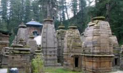
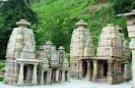
Binser The picturesque summer resort of the erstwhile Chand rulers, at an impressive height of 7913 ft. Provides a merizing view of the major Himalayan peaks-Trishul, Nanda Davi, Chaukamba and Shivling. KatarmalSunTemple 17 Kms away on Almora Ranikhet route across the Kosi River. It’sa complex of nearly 50 stone temples dedicated to Sun God. The impressive Surya Temple is situated at an altitude of 2116Mts dating back to 12th century. Lakhudiyar Literally means one lakh caves. This is one of the most important pre-historic sites in the hill. Fascinating pre- historic rock paintings are discovered within the caves. It’s at a distance of 20 Kms from the Almora. Kasar Devi -: The snow-capped peaks of the Himalayas are visible from the temple premises. The temple at north of the city is on the Kashap Hills. It’s mentioned the Puranas that the Goddess Durga took from of the Kaushiki here to kill the demons Shumbha and Nishumbha. It’s also believed to be the place of enlightenment of Swami Vivekananda. It attracts tourists from around the world. Udyochandeswar -: Is a beautiful Temple of Lord Shiva, the presiding deity of the Nanda Devi Sanctuary region. Deer Park -: At a distance of 3 Kms set amidst the idyllic settings. It’s a popular tourist spot. Chitai - Golu Devta Temple -: There is another famous old temple nearby dedicated to Gollu Devta, the god of justice in the pantheon of the hill people. Chitai - Devi Temple -: At a distance of 8 Kms from Almora, this temple is most revered by the people of the area. Beautiful bells adorn the temple. The Chitai Devi is the presiding deity of the Kumaon region. Accommodation -: Tourist Rest House Private Resort, Hotel & Himadri Camp Site. Kausani
At a height of 1890 Mts above sea level, amidst dense pine forests, it offers a majestic view of the Himalayas. Mahatma Gandhi spent a fortnight here when he was writing the Sumitra Tratise ‘Ana-Shakti Yoga’. Ana-Shakti Ashram is built in his memory. Famous Hindi Poet Nandan Pant belonged to this beautiful town.
Accommodation -: Tourist Rest House Private Resort, Hotel & Himadri Camp Site. |
Jageshwar
The massive temple complex of Jageshwar is at a distance of 35 Kms on Almora-Pithoragarh road. A pantheon of Hindu God and Goddesses is present here in the natural surrounding of Deodar trees. The idols of Surya, Neelkanth and Pushti Devi adorn this place. Pilgrims take a dip in the Nandini and Surabhi Rivers flowing below. Grand fairs are held during Shivratri (February-March) and Sawan (July-August). Accommodation -: Tourist Rest House Private Resort, Hotel & Himadri Camp Site. |
Ranikhet : Mini Europe

Ranikhet reflects the very best of the heavenly Himalayas : their lush green forest, majestic mountain peak, exotic plant, life and attractive wide life. To see nature and its elements in full harmony, the right place to be is Ranikhet. According to a popular belie, this spot had won the heart of Rani Padmini queen of Raja Sudhardev. She chose this scenic place to be her abode and since then, it has come to be known as Ranikhet, literally “Queen’s Field”. At an altitude of 1829 mts, above sea level, this hill resort is undoubtedly a tourists’ paradise. The invigorating mountain breeze, the singing of birds, the panoramic view of the Himalayas – the sights, sounds and smells leave the onlooker spellbound. During the rains, flowers sprout up everywhere in rainbow colures, branches of trees stoop with ripened fruits and sunlight peeping through the mist and clouds endow and enchanting effect all across Ranikhet. As winter comes, the softly falling snowflakes cover the environs in sheets of pure whiteness. The charm of every season is irresistible in its own right. And this is what makes Ranikhet an all season destination.
General Information
Altitude -: 1829 mts. (6000 Ft.)
Area -: 201.76 Sq. Kms.
Languages -: Hindi, English & Kumaoni
Season -: Round the year
Accessibility -:
Rail: Nearest Rail Head - Kathgodam - 87 Kms and Ram Nagar 96 Kms.
Road: well connected by road
Almora – 50 Kms, Nainital – 68 Kms, Delhi - 279 Kms,
Local transport : Taxi and State Govt. Bus Services.
Accommodation -:
Tourist Rest House
Private Resort, Hotel & Himadri Camp Site.
|
Excursions from Ranikhet
Chaubatia : 10 kms. Away and popularly known as orchard country commands a picturesque view of the Himalayas. Bhaludam: 3 kms. From Chaubatia, known for its artificial lake and picnic spots. Jhoola Devi Ram Mandir : 7 kms. From Ranikhet on the way to Chaubatia known for its temples devoted to the Goddess Durga and Lord Rama. Mankameshwar : This temple is attached to the Nar Singh Maidan (Ground), constructed by the Kumaon regiment. Opposite the temple is a Gurudware and a shawl factory. Upat and Kalika : 5 kms., from Ranikhet , on the main road to Almora is one of the best 9-hole golf courses in the area and is surrounded by lush pine forests. Nursery nearby are worth visiting. It could be an ideal location for film shooting. Hairakhan Temple (Chilianaula) : 4 kms., from Ranikhet is famous for the temple of Baba Haira Khan. It commands a panoramic view of the Himalayas. Tarikhet : 8 kms., from Ranikhet is a well known for its Gandhi Kuti, and the temple of Golu Devta is venerated in the Kumaon region. Binsar Mahadev : 19 kms., from Ranikhet on the way to Ramnagar and 2 kms. From Sonidant, amidst dense Pine and Deodar forest. The Shiva Temples of Binsar Mahadev are a unique place for meditation and picnics. Bhikiasain : 55 kms. From Ranikhet is famous for its Maha Savitri Fair. Manila : Manila is 87 Kms from Ranikhet & 75 Kms from Ramnagar. Manila if the seat of Manila Devi- the family Goddess of the Katyuri clan. The forest and the Himalayan view from this hill is enchanting. Majkhali : 13 kms., from Ranikhet, on the way to Almora, Majkhali offers a close view of the snowy heights. Dwarahat : 37 kms. From Ranikhet, the once Principsl sear of the Karyuri Rajas is Dwarahat. Apart from temoles it is full of ancient sculptures. It is also known for its Syaldeh Bikhoti fari (13th to 15th April every year). Chaukhutia : Chaukhutia is famous for its natural beauty and fishing centre. It is about 54 kms. Enroot to Badrinath Naithna Devi : 35 Kms from Chaukhatia, 34 kms. From Bhikiasan and 54 kms. From Ranikhet the famous temple os Durga is situated at a 4 kms. Walk from Dola village. Jaurasi : 16 kms, from Chaukhutia, Jauriasi is famous for its panoramic view. Khairna : 22 Kms from Ranikhet on the Nainital riute, it is famous for fishing. Doonagiri : Doonagiri is a place of religious importance. It is famous for its temples of Durga from where one can have a good ciew of Someshwar and Gogas valleys. Pandukholi : It is 10 kms., from Doonagiri. From Manglikhan to Kukuchhhina you can come by bus.The remaining distance is a 5 kms. Walk. Here caves built by the Pandavas are worth watching. Bharkot Ka Pahaar : This Mountain is the highest in Kumaon Region. It can be easily seen from Doomagiri. Sukhdev Muni Ashram : 2 Kms. From Doonagiri Syjhdev Muni’s Ashram is a quiet spot. Accommodation -: Tourist Rest House Private Resort, Hotel & Himadri Camp Site. |
